NH48 Info
Mountain info, routes, and photo metadata for New Hampshire’s 48 four-thousand-foot peaks. Browse the catalog, explore White Mountain trails, discover long-distance hiking routes, and request authenticated API access when you need cloud fetches.
Main Menu
NH48 Catalog
Browse New Hampshire's 48 four-thousand-foot peaks with detailed elevation data, route information, and summit photos. Filter by difficulty, range, and completion status.

Current Conditions
Open a live NH48 planning view with weather overlays, radar, alerts, and a persistent summit detail panel for every peak.

White Mountain Trails
Interactive map and trail finder for the White Mountain National Forest. Track completion progress, view trail details, and explore routes with real-time filtering.
Long Trails
Discover long-distance hiking trails across North America. View trail segments, elevation profiles, and route details for scenic thru-hikes and backpacking adventures.
Howker Plant Catalog
Explore alpine and subalpine plant observations from the Howker Ridge Trail, with species details, habitat notes, and photo references.
Last Modified: 07/08/2026
Howker Ridge Trail Info
Learn about the Howker Ridge Trail, including its history, elevation profiles, segments and points of interest.
Last Modified: 07/08/2026
NH48 Planning & Info
Start with the NH 4,000-Footers guide, then launch the interactive planner to build and reorder your trip templates.
Last Modified: 07/08/2026
Photo Games
Play through three ways to learn the peaks: classic matching, timed rounds, or a slower jigsaw mode.
Last Modified: 07/08/2026
NH52WAV
Browse New Hampshire’s 52 With a View peaks through the companion catalog with scenic list coverage, route details, and live peak pages.

White Mountains Visual Wiki
Browse connected mountain, plant, and animal entries in a visual field-guide format built for hikers and researchers.
Peak Catalog
NH48 Catalog
Browse New Hampshire’s forty eight four thousand footers as living mountain pages, not a bare checklist. Range by range, the catalog surfaces elevation, prominence, trail style, difficulty, exposure, and summit photography, then opens into full guides with route maps, weather context, parking notes, and field tested observations. Start here when you want the whole list to feel navigable rather than overwhelming.
- Live peak cards and range filters pull from the current NH48 catalog data.
- Cards surface elevation, prominence, trail type, and difficulty before you open the full mountain guide.
- Range browsing carries straight into guide pages with route maps, weather context, parking notes, and summit photography.
Server-rendered NH48 cards are filled into this panel before the route is served; filters remain an enhancement.
Current Conditions
Current Conditions
Check the lightweight live version of the NH48 Current Conditions page with a mini map, default temperature and alerts, summit hover details, and quick links into the full planning surface.
- Temperature and alert highlighting load first so the homepage preview stays useful without opening the full overlay stack.
- Hover, focus, or tap a summit marker to update the detail card and pin the peak you want to review.
- Primary and secondary actions jump straight into the full current-conditions page or the fullscreen NH48 map.
A cached conditions summary is filled into this panel before the route is served; live maps and alerts enhance later.
Access Roads
Access Roads Status
Review White Mountain National Forest road and trailhead access status before choosing a trailhead.
- Open, partial, and closed status counts load from the same access-status source used by the road report.
- Recent and linked trailhead context stays in the full report so this preview stays compact.
- Use this as a starting point, then verify important access details before driving.
A compact access summary loads lazily from the road-status cache.
Water Crossings
Water Crossing Data
Check focused stream gages, flow and stage readings, and crossing context for White Mountains planning.
- Fresh readings, source coverage, and nearby crossing context come from the water-conditions cache.
- Only a small, relevant summary appears here; the full report keeps the map and detail panels.
- Treat stream readings as planning context and verify actual crossings when you arrive.
Focused gage and crossing context loads lazily from the water-conditions cache.
Trail Explorer
White Mountain Trails
Pick a hiking area, then keep map, list, search, mileage, trail source, manager, and route shape filters in one shared view so you can compare options without losing your bearings.
- The map, trail list, and filters stay in sync, with stable links into the full explorer.
- NH48 remains the default opening region, while the preview can still switch into any manifest backed trail dataset.
Server-rendered trail summaries appear first; the interactive route map enhances on viewport intent.
Guide Layer
NH48 Guide
The guide is where the list becomes legible. It gathers the meaning of the NH48, range by range structure, classic day trip groupings, beginner picks, difficulty bands, seasonal and risk context, finish strategies, history, and the site’s data doorway into one readable planning spine. Read this before you sort peaks; it will change how you understand the whole project.
- Guide tables and grouping cards draw from the same datasets that feed the planner and live peak pages.
- The preview separates understanding the list from arranging trips, so visitors can learn the mountain families before launching the planner.
- Range filters, table rows, and grouping cards mirror the live guide structure rather than a thin homepage summary.
Range filters and compact guide rows will appear here from the live guide and planner grouping data.
Long-Distance Routes
Long Trails
The long trails system brings together the Appalachian Trail, Pacific Crest Trail, Continental Divide Trail, Arizona Trail, and other long campaigns with stable URLs, downloadable geometry, and section level metadata so immense routes become browsable one piece at a time. It invites big trail thinking without sacrificing structure.
- Section cards, mini maps, and exports all point back to the same route dataset.
- Preview routes surface section links, geography, and route identity before you open the full explorer.
Compact route cards and a mini long-trails map hydrate here from the generated section datasets.
Howker Flora
Howker Plant Catalog
This catalog follows Howker Ridge from alpine bilberry to bog plants, shrubs, mosses, and year round lichens, organized by habitat, season, and growth form with photo backed observations and field notes. Open it when you want the ridge to read not just as a route, but as a living ecological gradient.
- Habitat, season, and type filters turn the trail into a browsable field notebook.
- Species cards come from the live Howker plant catalog, with real images, notes, and habitat cues.
A live subset of the Howker plant catalog hydrates here with real species cards and type filters.
Trail Narrative
Howker Ridge Trail Info
Howker Ridge is presented here as a real mountain narrative rather than a generic hard hike blurb. The page tracks the climb from Bumpus Brook cascades and Devil’s Kitchen to the four scrambling Howks, ecological shifts, viewpoints, history, bailout options, loop variations, and the high alpine finish on Mount Madison beside the Appalachian Trail. Open this when you want terrain, story, and decision making in the same place.
- Live points of interest, route metrics, and map links keep the page anchored to the trail itself.
- Points of interest, highlights, and route context come from the same trail data files used on the destination pages.
- The panel still previews the narrative guide and the interactive map without trying to embed the whole project at once.
Route metrics, point-of-interest buttons, and a mini map preview load here from the live Howker Ridge data files.
Trip Building
NH48 Planning & Info
Planning here means more than sorting peaks by name. This hub pairs first hike guidance, day trip groupings, logistics and risk notes, and finish styles with a drag and group planner that lets you reorder all forty eight peaks into realistic trips before you export the sequence. It is equal parts strategy board, field notebook, and long game companion.
- Build trip blocks, collapse groups, and shape a finish strategy before the calendar fills in around you.
- The preview stays lightweight on the homepage while reflecting the same planning templates and grouped day trip families used in the full planner.
- Guide notes and planner actions stay aligned so visitors can move from strategy to itinerary without losing context.
Strategy filters and draggable itinerary groups hydrate here from the NH48 planner template data.
Photo Learning
Photo Games
The site’s photo archive becomes a training ground here. Match summit images to the right peak across the eight round PeakID game, race falling photos against the clock in timed mode, or rebuild a mountain as a jigsaw from real NH48 imagery. Playful on the surface, these modes quietly teach visual fluency with the mountains themselves.
- Three ways to learn the peaks: memory, speed, and pattern recognition.
- Each mode uses real summit photography from the NH48 archive rather than generic game art.
- The homepage preview lets visitors sample the game family before opening the full PeakID, timed, or puzzle experience.
Server-rendered game mode summaries appear first; playable previews enhance with real mountain photos.
Companion List
NH52WAV
The companion list widens the horizon beyond the four thousand footers without lowering the level of detail. Searchable, range grouped cards lead into live NH52WAV peak guides with route context, trail maps, weather baselines, planning notes, and summit photography, making these scenic peaks feel like a true second landscape to explore rather than an afterthought.
- A broader New Hampshire mountain catalog, built with the same guide logic as the flagship NH48 pages.
- The homepage preview uses the real NH52WAV catalog renderer, search flow, and range slices.
- Direct peak links carry visitors from the companion list into full guide pages with maps, planning notes, and mountain imagery.
Searchable NH52WAV cards hydrate here using the same renderer and mountain data as the full catalog.
Field Guide Network
White Mountains Visual Wiki
This is the site’s knowledge web rather than its checklist. The visual wiki links NH48 mountains, NH52WAV peaks, plants, animals, and forest health threats into a browsable field encyclopedia, so a hike can unfold sideways, from summit to species, from forest type to disease pressure, from scenery to system. It is the best doorway for turning trail fascination into mountain literacy.
- Browse a mountain, then follow the links outward into flora, fauna, and the changing condition of the forest.
- The panel exposes live category counts and entry links from the same wiki datasets used on the destination pages.
- Visitors can move between mountains, plants, animals, and forest health while keeping the broader field guide context in view.
Live entry counts, category toggles, and connected wiki links hydrate here from the current mountain, plant, animal, and forest-health datasets.
NH48 is a guide-first hub for New Hampshire 4,000-footers and the wider White Mountains, with peak pages, trail tools, range catalogs, photos, and authenticated API access for cloud fetches.
About NH48, the guides, and the data
About NH48, the guides, and the data

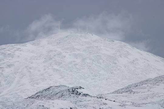
Forested ridgelines and alpine terrain in the Presidential Range.
(c) Nathan Sobol; Canon EOS 5DS R; 1 sec, ISO 100; captured Aug 28, 2025. Home -> Peak Catalog -> Mount Adams
NH48.info is a volunteer‑run White Mountains reference centered on New Hampshire’s 48 four‑thousand‑foot peaks. The site now combines detailed peak guide pages, route and trail context, range-level browsing, photo-rich summit coverage, and a growing visual wiki for hikers, planners, researchers, and curious mountain people.
Most of the site is meant to be read like a normal guide first. You can open a peak page for elevation, prominence, routes, nearby links, photos, and map context, then branch into the trail explorer, range catalog, or wiki when you want a wider view. For builders and data users, authenticated API access is available for NH48 and NH52WAV when you need cloud fetches and managed keys.
Send Edit to Author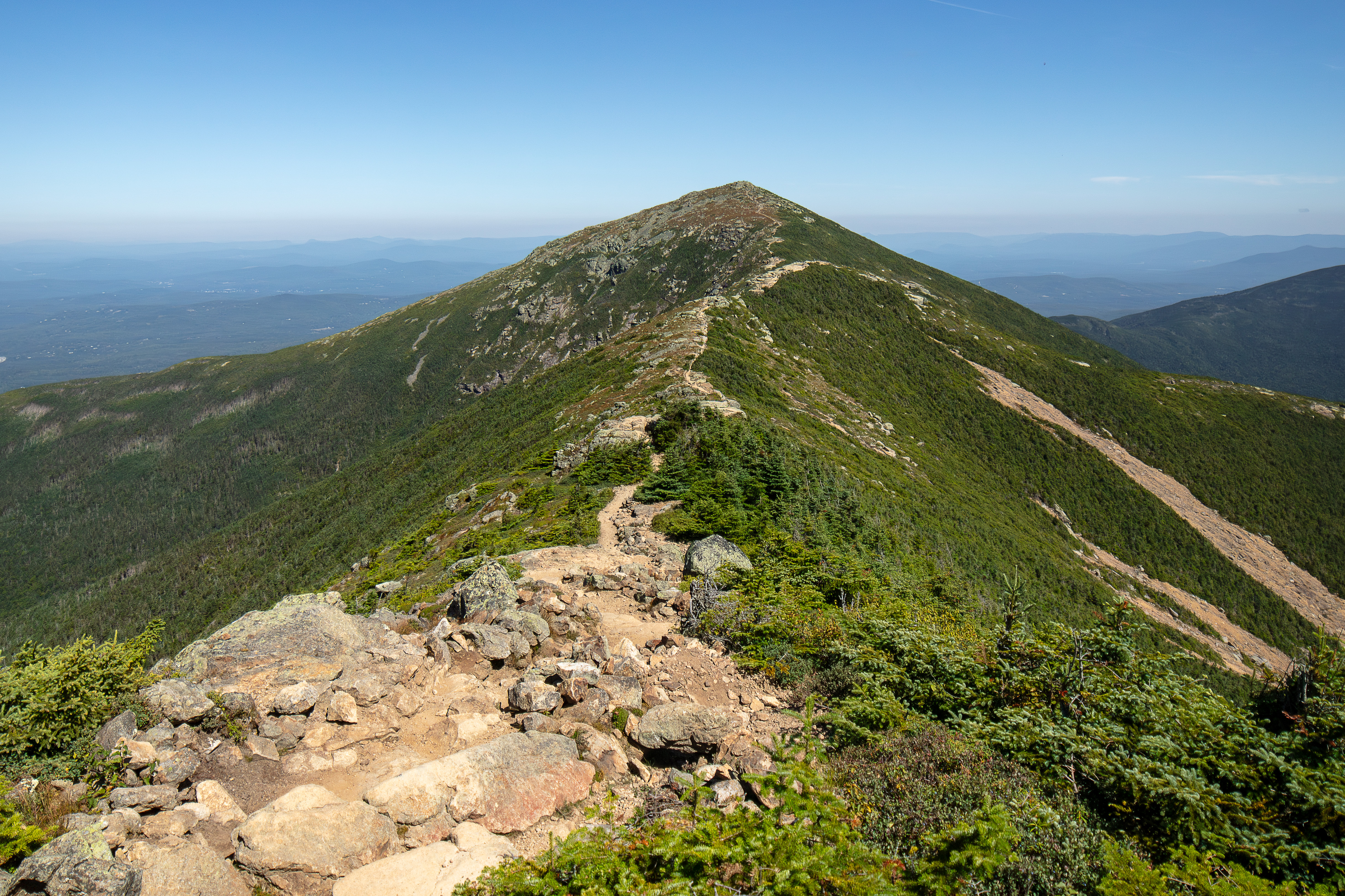
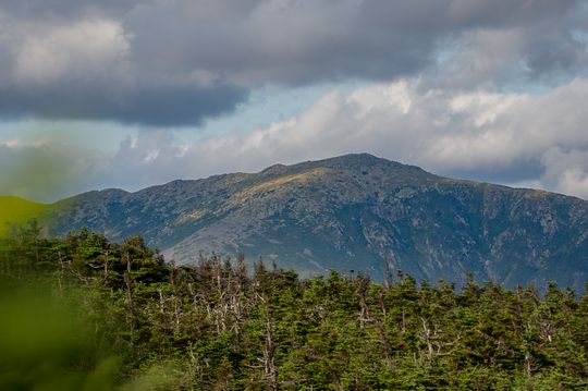
Franconia Ridge terrain overlooking the White Mountains.
(c) Nathan Sobol; Canon EOS 5DS R; 1 sec, ISO 100; captured Aug 15, 2025. Home -> Peak Catalog -> Mount Lafayette
NH48 Peak Catalog – Browse all 48 peaks through dedicated guide pages with summit stats, route panels, range grouping, curated photos, and links into related trails and nearby peaks.
White Mountains Visual Wiki – Browse connected mountain, plant, and animal entries in a field-guide layout with internal links between peaks, trails, and natural history.
Range Catalog – Compare the Presidential, Franconia, Carter-Moriah, Kinsman, Twins and Bonds, and other groups in one place when you want a broader view than a single summit page.

Pemigewasset Wilderness ridges with layered summit views.
(c) Nathan Sobol; Canon EOS 5D Mark IV; 35mm F1.4 DG HSM | Art 012, 1/125 sec, ISO 125; captured Jun 15, 2023. Home -> Peak Catalog -> Bondcliff
White Mountain Trails Explorer – Search and map official and unofficial trails across the White Mountain National Forest with segment-level distance, elevation gain, permitted uses, surface notes, and trailhead context.
Long Trails – Explore larger route systems such as the Appalachian Trail and Pacific Crest Trail with segment data, elevation profiles, and map geometry.
NH48 Photos – Browse mountain and trail photography with alt text, captions, and metadata that make the image archive useful for both people and machines.
API Access – Sign in with the shared NH48.app account system to review plan limits, manage keys, and fetch NH48 or NH52WAV from authenticated cloud endpoints.
Peak Planning Tool – Build day hikes and completion plans with route metrics, exposure context, and practical planning filters.
PeakID, Timed PeakID, and the Jigsaw Puzzle turn the photo archive into lighter-weight learning tools when you want a break from maps and stats.
Howker Ridge Plant Catalog – Document alpine and subalpine species along the Howker Ridge Trail with common and Latin names, habitat notes, bloom windows, elevation bands, and photo references.
Howker Ridge Trail Info – Read route history, elevation profiles, segments, and points of interest, then jump into the interactive map or the plant log map.
Because the site is maintained in spare time, conditions, closures, and land-management details can change. Please confirm current access and route status with official sources, and use the Send Edit to Author link if you spot something outdated or missing.
Photo use: Images are offered for non-commercial and educational use only; they remain the property of the site and may not be sold or printed without permission. For curated galleries and prints see NH48pics.com, and for peak-bagging progress and account tools see NH48.app.